GeoSample

Pro Analyzer

Online App

Save Time, Money, and Reduce Errors in Your Environmental Projects!

GeoSample Pro Analyzer revolutionizes environmental data management with intuitive Shiny app technology. Easily upload laboratory results for soil, groundwater, and more. Generate adaptable tables for data comparison against environmental guidelines. Identify critical concentrations, aiding in comprehensive environmental assessments. Customize output with flexible table options. Reduce project execution time, cut costs, and enhance report accuracy. Streamline your environmental projects with this invaluable tool
GeoSample Pro Analyzer

Discover GeoSample Pro Analyzer: A Guided Video Tour

Why GeoSample Pro Analyzer is a Unique App in the Market

App customization

App Customization:

Tailor GeoSample Pro with client-specific features and interfaces for unique project needs and workflows, ensuring a personalized development experience.

Language Customization

Language Customization:

 Develop the app in client’s preferred language for a bespoke experience, ensuring streamlined communication and enhanced usability in the chosen language.

Friendly Interface

User-Friendly Interface Design:

Offers an intuitive interface with dedicated tabs for environmental parameters, ensuring smooth navigation and a straightforward user experience.

Phone_Responsive

Phone Responsive:

Adapts seamlessly across devices including desktops, tablets, and phones, offering universal accessibility and consistent usability for diverse users.

Enhanced_Remote_Access

Enhanced Remote Access:

Accessible from any location through web browsers without specific software, facilitating efficient and flexible remote workflows for users globally.

Customizable_Integrated_Guidelines

Customizable Integrated Guidelines:

Incorporate client-selected environmental guidelines for direct in-app reference, tailoring to specific regulatory needs and user preferences.

Customization_Features

Customization Features:

Extensive session-specific options including color and text editing, plus sample labeling for a personalized app experience tailored to project needs.

Secure_Server_Environment

Secure Server Environment:

Utilizes shinyapps.io’s secure hosting with SSL encryption and user authentication, ensuring robust data protection and security.

Downloadable_Results_and_Guidelines

Downloadable Results and Guidelines:

Easily download tables and guidelines as JPG images, supporting straightforward sharing and integration in reports or presentations.

Time_and_Cost_Savings_and_Error_Minimization

Time and Cost Savings and Error Minimization:

Streamline data handling and analysis for reduced project duration and costs. Automation minimizes errors, enhancing accuracy.

Continuous_Software_Updates

Continuous Software Updates:

Regular updates with the latest features and improvements, keeping the app current with technological advancements and industry standards.

Dedicated_Client_Support

Dedicated Client Support:

Robust support services for the app, offering tailored assistance, guidance, and solutions for client-specific use and challenges.

GeoSample Pro Analyzer: Powering Strategic Sectors.

Specialized Environmental Consultants

Utilizing GeoSample Pro Analyzer, environmental consultants can tackle complex challenges associated with contaminated soils and groundwater. This sophisticated tool provides in-depth analysis and comprehensive data management, enabling precise monitoring and evaluation of environmental conditions. With its capacity to handle vast datasets and generate detailed comparisons against environmental guidelines, consultants can offer nuanced, evidence-based solutions. The app streamlines workflows, ensuring timely and accurate decision-making for sustainable environmental practices. Its customizable features allow for tailored analysis, fitting the unique needs of each project and enhancing the overall impact of environmental strategies.

specialized Environmental Consultants

Researchers and Academics

Researches and academics

For researchers and academics focused on environmental science and field studies, GeoSample Pro Analyzer is a vital tool for in-depth soil and groundwater analysis. It enhances data-driven research, enabling precise investigation of contamination and ecosystem health. This tool supports scholarly work with advanced analytical capabilities, facilitating the understanding and resolution of complex environmental challenges related to soils and groundwater.

Governmental Agencies

GeoSample Pro Analyzer provides government agencies with a dynamic platform for enforcing environmental regulations and policies. By integrating real-time data analysis, the tool aids in proactive environmental management and policy-making. Its comprehensive features support the tracking and enforcement of regulatory compliance, helping agencies ensure that environmental standards are met. Enhanced data accuracy aids in strategic planning and public reporting, fostering transparency and trust in environmental governance. This tool is a valuable asset for government entities aiming to safeguard environmental health and promote sustainable development.

Governmental Agencies

Specialized Industries

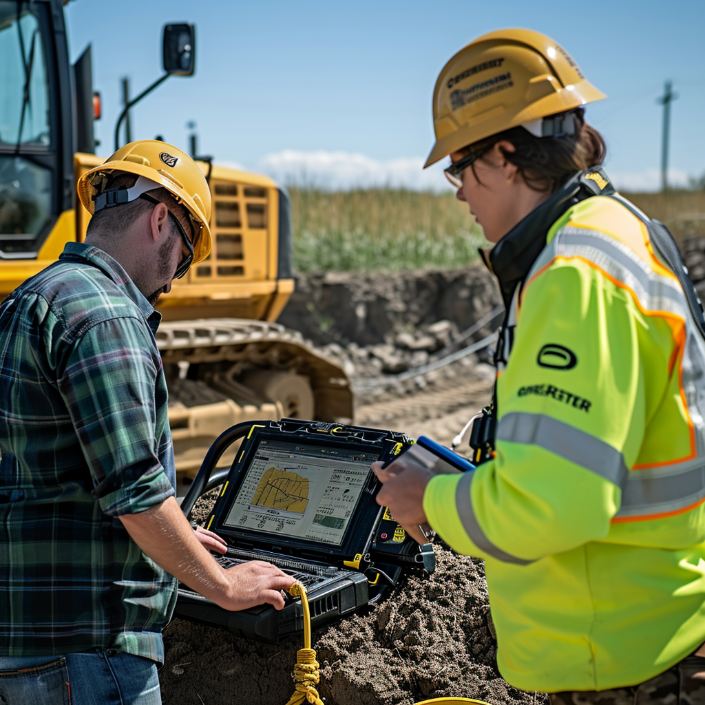
In sectors like mining, construction, and agriculture, GeoSample Pro Analyzer is vital for aligning industry activities with environmental responsibility, managing impacts, and ensuring compliance with sustainability goals. It provides detailed soil and groundwater analysis, crucial for preventing contamination and managing natural resources effectively. The tool’s adaptability allows for industry-specific customization, aiding businesses in making informed decisions that respect both their operational needs and the environment. Its use ensures that companies can continue their essential work while also protecting and preserving the ecological integrity of their surroundings.
Mining Industry

 Environmental Insights with Custom Shiny Apps

Pricing Section

Transparent Pricing, Customized for Your Needs

Our pricing is as clear as our commitment to your environmental goals, providing bespoke services for nuanced environmental projects. Each app is specifically designed for a particular laboratory’s data and operational procedures, ensuring tailored solutions for individual labs. Notably, our apps support only a specific guideline per installation, requiring separate apps for different guidelines within the same laboratory. This specialized approach guarantees seamless integration with each laboratory’s unique CSV file format and methodologies, bolstering the precision and usefulness of each analysis.

We uphold the highest standards of customization and quality by crafting each app for specific laboratory and guideline pairings. We offer a one-year contract for app usage, including an initial two-month trial period. This trial allows you to assess the app’s fit within your operations, providing the flexibility to cancel if it doesn’t meet your expectations. Our aim is to ensure you are completely confident in the app’s value and its seamless integration into your workflow.

Table 1: Initial Package and Add-Ons
Table2: Recurrent Costs and Additional Services
Note: prices do not include taxes and are subjects to final invoice.

Adding an Additional Laboratory

For those looking to expand their analytical capabilities across multiple laboratories and various guidelines, our commitment to precision and customization remains steadfast. With every new setup—be it a different laboratory or a new guideline within the same lab—we initiate a bespoke app development process. This ensures a perfect alignment with the unique data formats and analytical needs specific to each laboratory and guideline. As your project’s scope broadens to encompass a variety of laboratory types and guidelines, each app is meticulously tailored and integrated with the respective laboratory’s CSV file format and methodologies.

Our approach guarantees that each app is not only accurate but also dedicated to a single laboratory and guideline, ensuring the highest standards of specificity and quality:

  • New App Development for Additional Laboratory or Guideline: Same as initial package ($1,500)

  • Monthly Access Fee for Additional Laboratory: $75 per user, minimum 7 users ($525)

  • Additional Users for Additional Laboratory: $65/user

This model upholds the integrity and customization of our services, ensuring that as your project diversifies and grows, the quality and specificity of your analytical tools keep pace.

FAQs

After paying the $1,500 for the app development, do I own the app?

With the $1,500 payment, you are entitled to the development of a customized app, but you do not own the app. Instead, a lease agreement is established for one year.

What would be the total price for the app development if I want to add the basic soil package and the groundwater extra?

The basic package costs $1,500. Adding the groundwater package for hydrocarbons, metals, and salinity costs $300 per tab, amounting to $900. Therefore, the total price would be $2,400.

What is the cost of the app if I want to work with two different laboratories?

Each laboratory requires a customized app, leading to the creation of two separate apps, one for each laboratory. The cost per app is $1,500 (basic package), amounting to a total of $3,000 for two laboratories.

Is it feasible to utilize a single application for multiple guidelines within the same laboratory, or is it requisite to have distinct applications for each guideline?

No, it is requisite that each application is uniquely designed to adhere to a single guideline for one laboratory. In the instance of requiring management of multiple guidelines within the same laboratory, it is necessary to procure separate applications for each guideline.

Once the app development is completed, what do I need to pay?

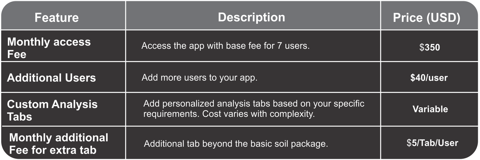
After the app’s development is finished, the cost will be $50 USD user/month, with a minimum requirement of 7 users. This equates to a minimum cost of $350 USD/month. Adding an additional user incurs an extra cost of $40 USD/month.

I would like to be able to add a tab that displays the location of samples on a map. Is this possible, and what would be the cost?

It is possible to add any type of custom tab, with the cost depending on the development hours required for the new tab. The minimum cost is $300.

What is the monthly recurring cost for two laboratories?

The cost is $75 USD per user per month. With a minimum of 7 users, the minimum cost is $525 USD/moth.  Any additional user incurs a cost of $65 USD/month.

What is the monthly cost for the basic package with an addition of three groundwater tabs?

The monthly cost for the basic package, accommodating a minimum of seven users, is $350. With the addition of three groundwater tabs, and considering the additional charge of $5 per tab per user, the total additional cost is $105. Therefore, the total monthly expenditure would be $455 for the basic package plus the three added groundwater tabs, covering at least seven users.

License & Terms of Use

GeoSample Pro Analyzer is proprietary software. All rights reserved.
Copyright © 2024 Marcel A. Cedrez

This software and its documentation are protected by copyright law.
Unauthorized use, copying, or distribution is prohibited.

A demo version is available for testing with sample data. Full functionality requires a subscription and custom configuration for your specific data format.

How to Use GeoSample Pro Analyzer

1) Disclaimer

Before accessing GeoSample Pro Analyzer, users must confirm that they have read and understood the terms of use as outlined in the disclaimer by checking the appropriate box and then clicking the ‘Accept’ button. Upon completing these steps, access to the app will be granted. This process ensures users are informed and agree to the terms, facilitating a responsible and informed use of the application.

2) Guidelines

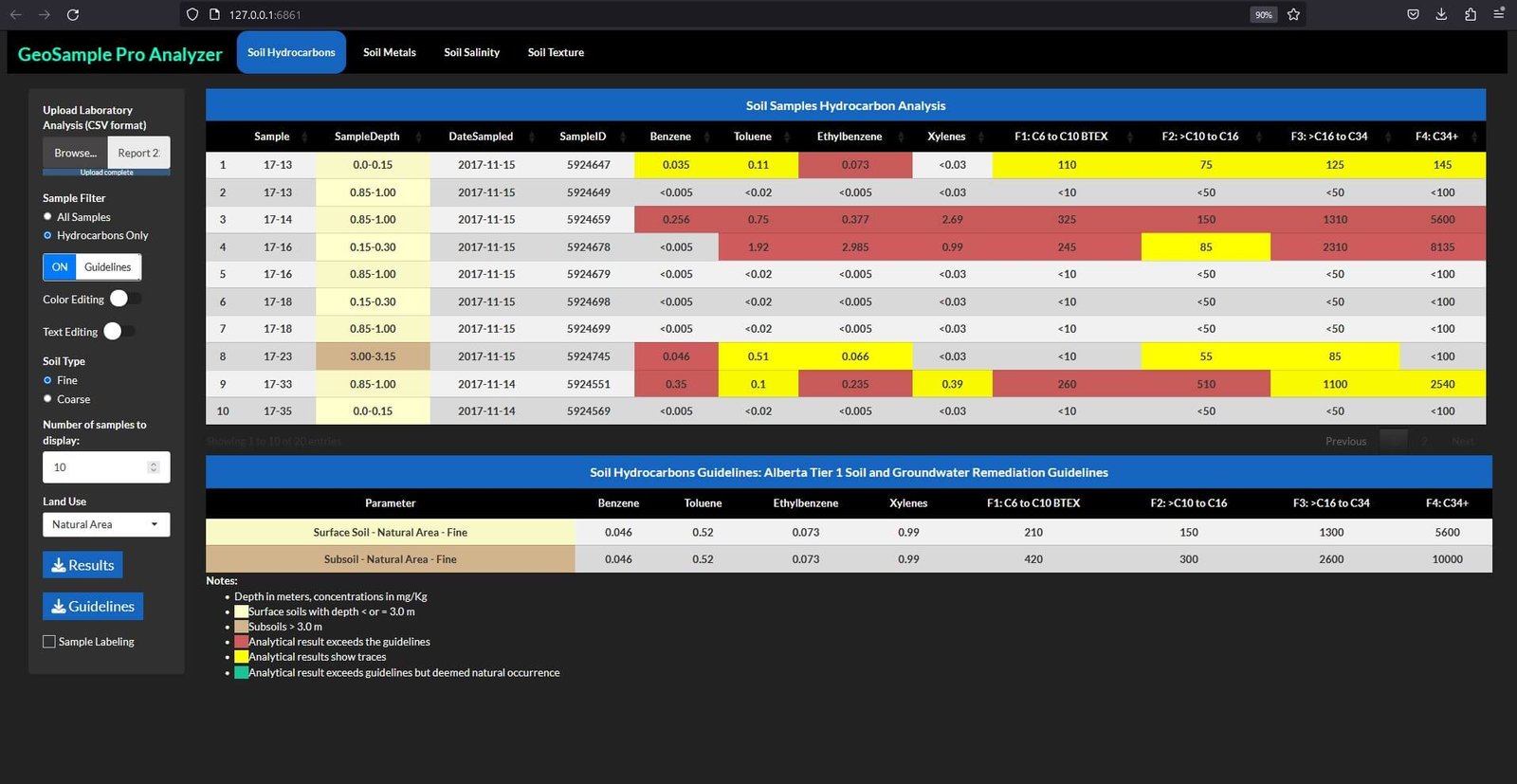
Upon accepting the disclaimer, users gain access to the GeoSample Pro Analyzer app. The main interface showcases four tabs: Hydrocarbons, Metals, Salinity, and Texture. The first three tabs focus on analyzing concentrations of parameters related to their respective labels, while the fourth tab delves into the texture of the analyzed sediments. These tabs display tables corresponding to the Alberta Tier 1 Soil and Groundwater Remediation Guidelines, offering insights based on specific scenarios.

The user interface allows the selection of a scenario that best fits the sampled site, considering both sediment granularity and land use. Each tab presents a range of scenarios in line with the possibilities outlined in the Alberta Tier 1 Guidelines. For instance, there are 20 potential scenarios for hydrocarbons, 10 for metals, and 6 for salinity. These scenarios can be fine-tuned using the “Land Use” and “Soil Type” options.

2.1) Downloading Guidelines Table

Once the appropriate scenario is set, the guidelines relevant to that scenario can be downloaded as a JPG image by clicking the ‘Guidelines’ button. This feature ensures that users can easily access and utilize specific guideline information tailored to their environmental analysis needs.

3) Lab Data

Once the appropriate scenario is selected in the GeoSample Pro Analyzer, users can seamlessly upload their laboratory data using the “Upload Laboratory Analysis (CSV format)” feature. This functionality exclusively supports CSV file formats, ensuring a standardized and efficient data import process. Upon successfully uploading the files, the app promptly displays a table containing the analytical results. This streamlined approach not only enhances user experience but also facilitates accurate and organized data presentation, crucial for environmental analysis.

3.1) Sample Filter

Upon accessing the GeoSample Pro Analyzer, users are initially presented with the ‘All Samples’ view. This default setting comprehensively displays all samples within the dataset, irrespective of the specific parameters analyzed. In this mode, while navigating a specific tab such as Hydrocarbons, the application will only show data for hydrocarbon parameters in samples where these were specifically analyzed. For other samples, the application maintains the essential information such as the sample number, depth, date of sampling, and unique identifier, but leaves the parameter-specific rows blank. This approach facilitates a holistic understanding of the entire dataset included in the CSV file.

For a more focused analysis, users can select the ‘Hydrocarbons Only’ option within the Hydrocarbons tab. This functionality filters the dataset to display only those samples that have been analyzed for hydrocarbons, thereby streamlining the analysis process. Selecting this option also activates additional features within the application, including ‘Guidelines’, ‘Color Editing’, and ‘Text Editing’. These tools are designed to enhance the user’s ability to customize and critically analyze the data, tailored to the specific requirements of their environmental assessment.

3.2) Number of samples to display

The “Number of Samples to Display” feature in the GeoSample Pro Analyzer adds a layer of customization for users, allowing them to specify the exact number of samples they wish to view in a table, with options ranging from 1 to 1000. This functionality becomes particularly useful for organizing tables by sampling locations within a site, such as the tank’s area, storage area, background area, and so on, as we will see later with the “Sample Labeling” option. It offers an efficient way to segment and analyze data based on specific site sections.

Additionally, the application provides a sorting feature for the columns of parameters. By simply clicking on the column header in the table, which displays the parameter name, users can sort the data in ascending or descending order. This sorting capability is crucial for quickly identifying samples with the highest concentrations of a particular parameter. It also allows for organizing samples by other criteria, such as depth. These functionalities enhance the user’s ability to rapidly assess and categorize environmental data, making the GeoSample Pro Analyzer a versatile and powerful tool for environmental analysis.

3.3) Guidelines switch

In the default setting of the GeoSample Pro Analyzer, the option for “Guidelines” is initially turned off. Users can activate this feature with a simple click, enabling it to the ‘on’ position. Upon activation, the application engages in a comparative analysis, meticulously matching the analytical results from the table with the user-defined guidelines. Should any sample concentrations surpass the specified reference levels, the app highlights these instances by color-coding them. This color-coding is not arbitrary but is based on the specifications outlined in the footnotes ofthe guidelines table. This function aids in swiftly identifying and focusing on key data points that exceed environmental standards, thereby enhancing the efficiency and precision of data analysis within the application.

3.3.1) Color Editing

The “Color Editing” function in the GeoSample Pro Analyzer, a user-activated feature, offers the ability to modify table cell colors during a user session. Upon activation, two additional options become available: “Choose Cell Color” and “App Colors Used”. Selecting “Choose Cell Color” opens a color picker, allowing users to choose their desired color. The “App Colors Used” button reveals a dropdown with codes of colors utilized within the app, which can be copied and pasted into the color picker. This feature is especially useful for users wishing to apply app-specific colors to their data.

Any color alterations made are maintained throughout the session, even if the “Color Editing” switch is deactivated, and can be re-edited if the switch is reactivated. However, these modifications are session-specific and revert to their original state once the session ends, ensuring the preservation of the app’s original color scheme for future sessions.

This functionality is invaluable when used alongside the “Guidelines” switch. In cases where sample concentrations exceed guidelines due to natural occurrences rather than anthropogenic activities, users can alter the color of these specific cells to indicate natural occurrence. Additionally, “Color Editing” is beneficial in scenarios like deeper-than-usual topsoil, where the default app color might not accurately represent the situation. Overall, “Color Editing” enhances the app’s flexibility, allowing users to tailor data presentation to meet the specific needs of each analyzed site, thereby improving the accuracy and relevance of the data visualization.

3.3.2) Text Editing

The “Text Editing” switch in the GeoSample Pro Analyzer offers a functionality akin to “Color Editing,” but it is somewhat more restrictive in its application. This feature allows users to modify the content of the cells in the tables to better fit their specific needs. However, there is an important safeguard in place: once the “Text Editing” switch is turned off, any changes made will automatically be reversed, restoring the values to their original state.

This automatic reset serves as a protective measure. It’s particularly crucial because the alterations made through this feature can involve critical data points, such as concentration levels or adjustments to values based on the application’s standards, like topsoil/subsoil distinctions or SAR/EC ratings. By ensuring that these modifications are not permanently saved, the GeoSample Pro Analyzer maintains the integrity of the original data, allowing for temporary adjustments for analysis or presentation purposes without the risk of permanently altering vital information. This careful balance between flexibility and data integrity makes the “Text Editing” function a valuable tool for users who require temporary, situational modifications to their data presentation.

3.4) Downloading Results Table

In the GeoSample Pro Analyzer, once a user has tailored the table to their specific requirements, downloading the customized data is straightforward and efficient. By simply pressing the “Results” button, the table is promptly downloaded in a high-quality JPG format. This feature ensures that users have a convenient way to save and share their tailored data visualizations, maintaining the clarity and precision of the information in a widely accessible and easily distributable format. This functionality is particularly valuable for professionals who need to include these tables in reports or presentations, providing them with a quick and reliable method to extract and utilize their data.

3.5) Sample Labeling

The “Sample Labeling” function in the GeoSample Pro Analyzer adds a significant level of customization to the data presentation. Upon selecting the “Sample Labeling” checkbox, the app generates a new table that is identical to the original but with an added feature: a new column at the beginning labeled “SampleArea.” This column is specifically designed to offer users an extra layer of personalization in the analytical results table.

The addition of the “SampleArea” column allows for enhanced labeling and categorization of samples, which is enabled through the “Sample Editing” switch that appears right after the “Sample Labeling” checkbox is checked.

3.5.1) Sample Editing

When the “Sample Editing” switch is activated in the GeoSample Pro Analyzer, it opens up a dynamic feature for organizing data more effectively. Users can add names within the “SampleArea” column, which allows for sorting and categorizing the samples based on their specific sampling locations. The beauty of this functionality is in its persistence; any names or organization applied to the “SampleArea” column remain intact throughout the session, even if the “Sample Editing” switch is later turned off. Users can revisit and edit these cells anytime as long as the switch is reactivated.

However, it’s important to note that the information in the “SampleArea” column is not permanent. At the end of the session, this column will reset, ensuring that each new session starts with a clean slate. This feature is particularly useful for environmental professionals who need to handle complex datasets with multiple sampling areas and require a clear, session-specific organization.

Additionally, the table generated with the “Sample Labeling” switch includes all other functionalities previously described. This means users have the full suite of tools at their disposal, enhancing the app’s versatility and user-friendliness. The combination of “Sample Editing” with other features like “Color Editing” and “Text Editing” makes the GeoSample Pro Analyzer a robust tool for detailed and personalized environmental data analysis.